
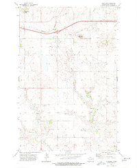
1960 Map of White Butte NE
USGS Topo · Published 1962About this map
The Heart River meanders sharply across the northern reaches of this Stark and Hettinger County landscape, its course marked by a narrow green riparian corridor that cuts through the surrounding prairie. This area, surveyed for the Department of the Interior's Missouri River Basin development program, reveals a rural landscape defined by drainage patterns and topographic relief. Central to the local community is St Stephens Ch, positioned on a high point between the river valley and the southern uplands. To the south, the terrain rises into the Lime Hills and the Campbell Highland, where the elevation provides a distinct contrast to the lower creek beds of Plum Creek and Buffalo Creek. The presence of several Gravel Pit sites suggests the local importance of aggregate extraction for road building in this sparsely settled region.
Find a feature on this map
12 named features on this map. Tap any name to fly to it.
Don’t see what you’re looking for? This feature index may not catch every label — zoom into the map to look around manually.
Map Details
Editions of this 1960 White Butte NE Map
This is the sole edition of this map. No revisions or reprints were ever made.
Other maps of this area

1953 · Dickinson
USGS Topo · 1:250,000

1957 · Dickinson
USGS Topo · 1:250,000

1960 · White Butte West
USGS Topo · 1:24,000

1960 · White Butte NW
USGS Topo · 1:24,000

1960 · Clark Butte NW
USGS Topo · 1:24,000

1960 · Clark Butte SW
USGS Topo · 1:24,000

1960 · White Butte East
USGS Topo · 1:24,000

1973 · Bratburg Butte
USGS Topo · 1:24,000

1973 · Richardton SE
USGS Topo · 1:24,000
1973 · Antelope
USGS Topo · 1:24,000