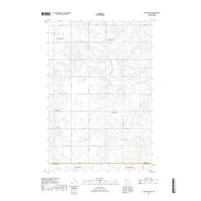
2018 Map of Clark Butte NW
USGS Topo · Published 2018About this map
The Heart River meanders across this rural landscape, joined by seasonal tributaries including Buffalo Cr, Spring Cr, and Government Cr. This 2018 survey shows a region defined by a strictly surveyed section-line road network, where gravel routes such as 85th Ave SW and 54th St SW provide access to the vast agricultural plateaus and coulees. The southern edge of the map is defined by the Stark Co Hettinger Co boundary, marking the transition between these two southwestern North Dakota counties. The terrain is characterized by the rolling breaks and drainage basins of the Heart River valley, with the local infrastructure—including Burt Rd—supporting the ranching and farming operations that comprise the primary human activity in this corner of the state.
Find a feature on this map
27 named features on this map. Tap any name to fly to it.
Don’t see what you’re looking for? This feature index may not catch every label — zoom into the map to look around manually.
Map Details
Editions of this 2018 Clark Butte NW Map
This is the sole edition of this map. No revisions or reprints were ever made.
Other maps of this area

1953 · Dickinson
USGS Topo · 1:250,000

1957 · Dickinson
USGS Topo · 1:250,000

1960 · Clark Butte NW
USGS Topo · 1:24,000

1960 · Clark Butte NE
USGS Topo · 1:24,000

1960 · White Butte NE
USGS Topo · 1:24,000

1960 · Clark Butte SW
USGS Topo · 1:24,000

1960 · White Butte East
USGS Topo · 1:24,000

1960 · Clark Butte
USGS Topo · 1:24,000
1973 · Hebron SE
USGS Topo · 1:24,000

1973 · Richardton SE
USGS Topo · 1:24,000