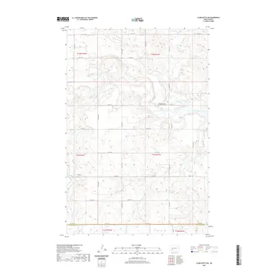
2020 Map of Clark Butte NW
USGS Topo · Published 2020About this map
The Heart River meanders across this rural landscape in southwestern North Dakota, providing a vital water source in a region defined by its section-line road network. The map reveals a deeply etched topography where Government Cr, Buffalo Cr, and Spring Cr drain into the river valley, shaping the high plateaus of the Missouri Slope. A significant landmark for genealogical research is the Bethesda German Congregational Cem, situated near the riverbanks north of 49th St SW. This cemetery serves as a physical record of the German-Russian heritage common to the homesteading families who settled this area of Stark and Hettinger counties. The survey clearly delineates the border between Stark Co and Hettinger Co along 54th St SW, capturing the persistent agrarian structure of the northern Great Plains.
Find a feature on this map
28 named features on this map. Tap any name to fly to it.
Don’t see what you’re looking for? This feature index may not catch every label — zoom into the map to look around manually.
Map Details
Editions of this 2020 Clark Butte NW Map
This is the sole edition of this map. No revisions or reprints were ever made.
Other maps of this area

1953 · Dickinson
USGS Topo · 1:250,000

1957 · Dickinson
USGS Topo · 1:250,000

1960 · Clark Butte NW
USGS Topo · 1:24,000

1960 · Clark Butte NE
USGS Topo · 1:24,000

1960 · White Butte NE
USGS Topo · 1:24,000

1960 · Clark Butte SW
USGS Topo · 1:24,000

1960 · White Butte East
USGS Topo · 1:24,000

1960 · Clark Butte
USGS Topo · 1:24,000
1973 · Hebron SE
USGS Topo · 1:24,000

1973 · Richardton SE
USGS Topo · 1:24,000