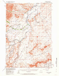
1950 Map of Clark
USGS Topo · Published 1963About this map
The Clarks Fork Yellowstone River carves a central path through this Wyoming-Montana borderlands landscape, defining a valley where early ranching and petroleum interests intersected. Agriculture is represented by numerous named holdings such as Gruenig Ranch, Forsman Ranch, and Johnson Ranch, many of which relied on irrigation ditches drawing from the river and its tributaries. Local civic life is anchored at the Clark Sch and the nearby Clark Cem, while more remote education was provided by the Pioneer Sch and Paint Creek School.
Find a feature on this map
38 named features on this map. Tap any name to fly to it.
Don’t see what you’re looking for? This feature index may not catch every label — zoom into the map to look around manually.
Map Details
Editions of this 1950 Clark Map
3 editions found
Other maps of this area

1944 · Red Lodge
USGS Topo · 1:62,500

1949 · Pat O'Hara Mountain
USGS Topo · 1:62,500

1949 · Cody
USGS Topo · 1:62,500

1950 · Clark
USGS Topo · 1:62,500

1950 · Deep Lake
USGS Topo · 1:62,500

1951 · Cody
USGS Topo · 1:62,500

1954 · Billings
USGS Topo · 1:250,000

1955 · Cody
USGS Topo · 1:250,000

1956 · Mount Maurice
USGS Topo · 1:62,500

1957 · Billings
USGS Topo · 1:250,000