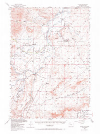
1950 Map of Clark
USGS Topo · Published 1971About this map
The Clarks Fork Yellowstone River carves a deep path through Park County, Wyoming, just south of the Montana state line. This mid-century landscape reflects a transition between established cattle ranching and modern industrial development. A series of family-named holdings, including the Johnson Ranch, Owen Ranch, and Noble Ranch, line the river's path, while the rise of the energy industry is marked by a Refinery situated within Badger Basin. Local social life centers on the settlement of Clark, supported by the Clark Sch and the Clark Cem. The topography is defined by prominent landforms such as Sugarloaf Butte and the broad elevated planes of Chapman Bench and Kimball Bench. To the southeast, the terrain breaks into the eroded profiles of the Badland Hills, with numerous drainage systems like Big Sand Coulee and Pat O'Hara Creek shaping the valley floor.
Find a feature on this map
37 named features on this map. Tap any name to fly to it.
Don’t see what you’re looking for? This feature index may not catch every label — zoom into the map to look around manually.
Map Details
Editions of this 1950 Clark Map
3 editions found
Other maps of this area

1944 · Red Lodge
USGS Topo · 1:62,500

1949 · Pat O'Hara Mountain
USGS Topo · 1:62,500

1949 · Cody
USGS Topo · 1:62,500

1950 · Clark
USGS Topo · 1:62,500

1950 · Deep Lake
USGS Topo · 1:62,500

1951 · Cody
USGS Topo · 1:62,500

1954 · Billings
USGS Topo · 1:250,000

1955 · Cody
USGS Topo · 1:250,000

1956 · Mount Maurice
USGS Topo · 1:62,500

1957 · Billings
USGS Topo · 1:250,000