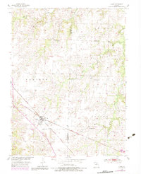
1953 Map of Clark
USGS Topo · Published 1983About this map
The railroad junction at Clark serves as the focal point of this North Missouri landscape, where the Norfolk and Western and Illinois Central Gulf lines intersect. Surveyed in the early 1950s with updates through the 1970s, the map reveals a transition between the open Prairie and the more dissected terrain of the Saling and Union townships. This area sits at a significant tri-county boundary where Randolph, Monroe, and Audrain Counties meet, a fact reflected in the clusters of rural institutions that once anchored these farming communities. Genealogists will find several notable landmarks, including the Chacel Grove Cem south of town and several country houses of worship and education such as New Hope Ch, Pleasant Grove Ch, and the Macedonia Sch. The drainage of the land is defined by the winding paths of Big Creek and Sailing Branch, which cut through the northern and eastern portions of the quadrangle.
Find a feature on this map
21 named features on this map. Tap any name to fly to it.
Don’t see what you’re looking for? This feature index may not catch every label — zoom into the map to look around manually.
Map Details
Editions of this 1953 Clark Map
3 editions found
Other maps of this area

1890 · Moberly
USGS Topo · 1:125,000

1917 · Sturgeon
USGS Topo · 1:62,500

1945 · Centralia
USGS Topo · 1:62,500

1952 · Middle Grove
USGS Topo · 1:24,000

1953 · Moberly
USGS Topo · 1:250,000

1953 · Renick
USGS Topo · 1:24,000

1953 · Clark
USGS Topo · 1:24,000
1953 · Moberly
USGS Topo · 1:24,000

1954 · Moberly
USGS Topo · 1:250,000

1957 · Moberly
USGS Topo · 1:250,000