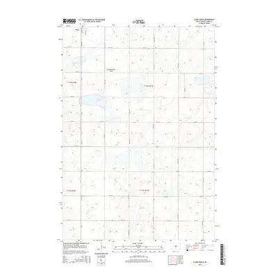
2015 Map of Clark South
USGS Topo · Published 2015About this map
The town of Clark anchors the northwestern corner of this South Dakota landscape, where the street grid of S Smith St and S Cloud St transitions quickly into a vast rural expanse. This 2015 survey reveals a terrain defined by glacial potholes and prairie wetlands, most notably the water bodies of Mud Lake and Antelope Lake. A significant portion of the central township is dedicated to the Clark County WPA, a waterfowl production area that preserves the natural character of the Coteau des Prairies. The map's grid-like road network, featuring routes such as Cr-46 and 424th Ave, follows the section lines of the Public Land Survey System, illustrating the orderly division of the Great Plains for agriculture and conservation.
Find a feature on this map
24 named features on this map. Tap any name to fly to it.
Don’t see what you’re looking for? This feature index may not catch every label — zoom into the map to look around manually.
Map Details
Editions of this 2015 Clark South Map
This is the sole edition of this map. No revisions or reprints were ever made.
Other maps of this area

1953 · Watertown
USGS Topo · 1:250,000

1958 · Watertown
USGS Topo · 1:250,000
1973 · Baileys Lake
USGS Topo · 1:24,000

1973 · Garden City
USGS Topo · 1:24,000

1973 · Willow Lake
USGS Topo · 1:24,000

1973 · Clark South
USGS Topo · 1:24,000
1973 · Clark North
USGS Topo · 1:24,000

1973 · Vienna West
USGS Topo · 1:24,000

1973 · Naples
USGS Topo · 1:24,000
1973 · Raymond SE
USGS Topo · 1:24,000