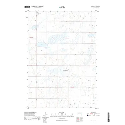
2017 Map of Clark South
USGS Topo · Published 2017About this map
Clark sits at the northern edge of this survey, serving as the primary hub for the surrounding agricultural landscape of Clark County. This region is part of the Coteau des Prairies, a vast upland plateau characterized by numerous glacial depressions and wetlands. The map clearly illustrates the density of these water bodies, ranging from smaller seasonal ponds to significant features like Antelope Lake and Mud Lake. The road network follows a strict sectional grid, with arteries such as Co Rd 54 and Co Rd 7 providing access across the township lines of t116n r58w and t115n r57w. The interplay between the engineered regularity of the county roads and the scattered, irregular wetlands defines the rural character of the South Dakota prairie in the early 21st century.
Find a feature on this map
23 named features on this map. Tap any name to fly to it.
Don’t see what you’re looking for? This feature index may not catch every label — zoom into the map to look around manually.
Map Details
Editions of this 2017 Clark South Map
This is the sole edition of this map. No revisions or reprints were ever made.
Other maps of this area

1953 · Watertown
USGS Topo · 1:250,000

1958 · Watertown
USGS Topo · 1:250,000
1973 · Baileys Lake
USGS Topo · 1:24,000

1973 · Garden City
USGS Topo · 1:24,000

1973 · Willow Lake
USGS Topo · 1:24,000

1973 · Clark South
USGS Topo · 1:24,000
1973 · Clark North
USGS Topo · 1:24,000

1973 · Vienna West
USGS Topo · 1:24,000

1973 · Naples
USGS Topo · 1:24,000
1973 · Raymond SE
USGS Topo · 1:24,000