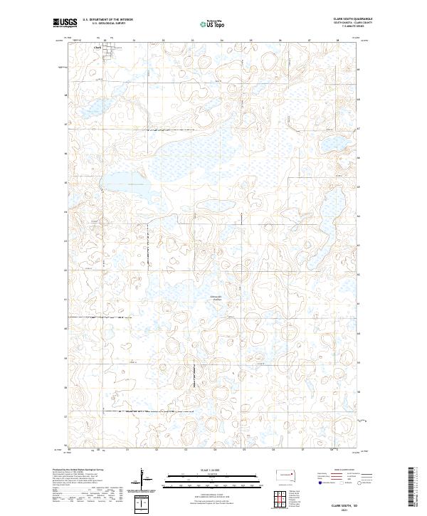
2021 Map of Clark South
USGS Topo · Published 2021About this map
The southern outskirts of Clark extend into a landscape defined by the glacial geography of the Coteau des Prairies. This upland plateau, known for its distinctive flat-topped elevation, is dotted with numerous prairie potholes and larger water bodies like Mud Lake and the expansive Antelope Lake. The map reveals a highly structured section-line road grid typical of the Great Plains, where routes like Co Rd 54 and Co Rd 7 navigate around the scattered wetlands. This 2021 survey provides a contemporary look at the intersection of agriculture and the natural hydrology of Clark County, showing how the local street system, including S Smith St and S Cloud St, transitions into the rural township and range divisions of t116n r58w and t116n r57w.
Find a feature on this map
23 named features on this map. Tap any name to fly to it.
Don’t see what you’re looking for? This feature index may not catch every label — zoom into the map to look around manually.
Map Details
Editions of this 2021 Clark South Map
This is the sole edition of this map. No revisions or reprints were ever made.
Other maps of this area

1953 · Watertown
USGS Topo · 1:250,000

1958 · Watertown
USGS Topo · 1:250,000
1973 · Baileys Lake
USGS Topo · 1:24,000

1973 · Garden City
USGS Topo · 1:24,000

1973 · Willow Lake
USGS Topo · 1:24,000

1973 · Clark South
USGS Topo · 1:24,000
1973 · Clark North
USGS Topo · 1:24,000

1973 · Vienna West
USGS Topo · 1:24,000

1973 · Naples
USGS Topo · 1:24,000
1973 · Raymond SE
USGS Topo · 1:24,000