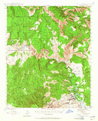
1944 Map of Clarkdale
USGS Topo · Published 1965About this map
Industrial and copper mining history dominates this 1944 survey of the Verde Valley, where the extensive workings of the United Verde Mine and the Daisy Mine define the landscape around Jerome. The map traces the critical infrastructure of the era, from the Hopewell Tunnel to the massive Smelter located just north of the company town of Clarkdale. The Santa Fe Railroad winds along the Verde River, connecting these mining hubs to Perkinsville in the northwest. Away from the industrial centers, the map documents a network of cattle tanks and trails, such as the Packard Trail, cutting through the Prescott National Forest and Kaibab National Forest. Cultural preservation is also noted at Tuzigoot Nat Mon, overlooking the river near Pecks Lake, providing a look at the intersection of ancient history and modern industry.
Find a feature on this map
65 named features on this map. Tap any name to fly to it.
Don’t see what you’re looking for? This feature index may not catch every label — zoom into the map to look around manually.
Map Details
Editions of this 1944 Clarkdale Map
5 editions found

Other maps of this area

1886 · San Francisco Mtns
USGS Topo · 1:250,000

1886 · Chino
USGS Topo · 1:250,000

1887 · Verde
USGS Topo · 1:250,000

1887 · Prescott
USGS Topo · 1:250,000

1891 · San Francisco Mtns
USGS Topo · 1:250,000

1891 · Chino
USGS Topo · 1:250,000

1892 · Verde
USGS Topo · 1:250,000

1892 · Prescott
USGS Topo · 1:250,000

1894 · San Francisco Mtns
USGS Topo · 1:250,000

1899 · San Francisco Mtns
USGS Topo · 1:250,000