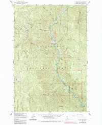
1963 Map of Clarke Mtn
USGS Topo · Published 1985About this map
The North Fork Clearwater River carves a deep, winding path through this portion of the Clearwater National Forest, serving as the primary corridor for movement and activity during the mid-20th century. Along its banks, the Bungalow Ranger Sta and Washington Creek Campground mark established points of forest administration and recreation. Higher elevations are anchored by significant peaks such as Elk Mountain and Deadhorse Mountain, the latter topped by a Fire Protection Road.
Find a feature on this map
42 named features on this map. Tap any name to fly to it.
Don’t see what you’re looking for? This feature index may not catch every label — zoom into the map to look around manually.
Map Details
Editions of this 1963 Clarke Mtn Map
2 editions found
Other maps of this area

1911 · Lolo
USGS Topo · 1:250,000

1913 · Lolo
USGS Topo · 1:250,000

1923 · Washington Creek
USGS Topo · 1:125,000

1956 · Hamilton
USGS Topo · 1:250,000

1959 · Hamilton
USGS Topo · 1:250,000

1960 · Hamilton
USGS Topo · 1:250,000

1963 · Sheep Mtn
USGS Topo · 1:24,000
1963 · The Nub
USGS Topo · 1:24,000

1963 · Clarke Mtn
USGS Topo · 1:24,000

1964 · Hamilton
USGS Topo · 1:250,000