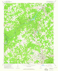
1964 Map of Clarkesville
USGS Topo · Published 1965About this map
Clarkesville and its surrounding communities in Habersham County serve as the focal point for this mid-1960s survey, illustrating the area's development along the Chattahoochee River and Southern Railway. The landscape is a network of small settlements and educational sites like Habersham Sch and Mud Creek Sch, alongside numerous spiritual centers such as Bethel Temple and Fairfield Ch. Local industry and infrastructure are evident through the Pardue Mill and the Powerplant at Habersham Mills Lake.
Find a feature on this map
78 named features on this map. Tap any name to fly to it.
Don’t see what you’re looking for? This feature index may not catch every label — zoom into the map to look around manually.
Map Details
Editions of this 1964 Clarkesville Map
3 editions found
Other maps of this area

1886 · Dahlonega
USGS Topo · 1:125,000

1886 · Walhalla
USGS Topo · 1:125,000

1891 · Gainesville
USGS Topo · 1:125,000

1891 · Carnesville
USGS Topo · 1:125,000

1892 · Dahlonega
USGS Topo · 1:125,000

1892 · Walhalla
USGS Topo · 1:125,000

1896 · Walhalla
USGS Topo · 1:125,000

1896 · Dahlonega
USGS Topo · 1:125,000

1903 · Dahlonega
USGS Topo · 1:125,000

1953 · Tallulah Falls
USGS Topo · 1:24,000