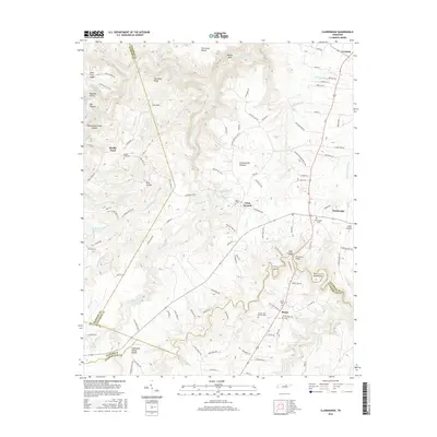
2016 Map of Clarkrange
USGS Topo · Published 2016About this map
The Cumberland Plateau dominates this portion of Middle Tennessee, where the Tennessee Valley Divide separates the headwaters of regional drainages. Local life centers on established communities like Clarkrange and Muddy Pond, with the southern landscape defined by the crossroads at Rinnie. The topography is marked by significant elevation changes, from the heights of Hurricane Ridge and Lost Mtn down into the deep recesses of Balden Gulf and The Horse Pound. The map provides a look at the rural infrastructure of the area, featuring numerous family and community landmarks such as the D O Beaty Bridge over Clear Cr and several local burying grounds, including Elmore Cem Number One and Mount Union Cem. This network of roads, including Old Martha Washington Rd and Old Bean Shed Rd, reflects the historic transit patterns across the plateau before modern highway development reshaped the region.
Find a feature on this map
131 named features on this map. Tap any name to fly to it.
Don’t see what you’re looking for? This feature index may not catch every label — zoom into the map to look around manually.
Map Details
Editions of this 2016 Clarkrange Map
This is the sole edition of this map. No revisions or reprints were ever made.
Other maps of this area

1895 · Wartburg
USGS Topo · 1:125,000

1896 · Wartburg
USGS Topo · 1:125,000

1897 · Standingstone
USGS Topo · 1:125,000

1898 · Standingstone
USGS Topo · 1:125,000

1935 · Isoline
USGS Topo · 1:24,000

1935 · Campbell Junction
USGS Topo · 1:24,000

1935 · Clarkrange
USGS Topo · 1:24,000

1936 · Fox Creek
USGS Topo · 1:24,000

1936 · Jones Knob
USGS Topo · 1:24,000
1946 · Fox Creek
USGS Topo · 1:24,000