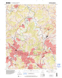
1996 Map of Clarksburg
USGS Topo · Published 2001About this map
Clarksburg anchors this mid-1990s landscape at the confluence of the West Fork River and Elk Creek. The urban core is flanked by industrial and residential expansions like Nutter Fort and Stonewood, while the surrounding terrain remains deeply marked by the extractive industries of Harrison County. Numerous coal-related labels including Strip Mine and various oil wells are interspersed with community landmarks like Pinnickinnick Mtn and Victory High Sch.
Find a feature on this map
89 named features on this map. Tap any name to fly to it.
Don’t see what you’re looking for? This feature index may not catch every label — zoom into the map to look around manually.
Map Details
Editions of this 1996 Clarksburg Map
This is the sole edition of this map. No revisions or reprints were ever made.
Other maps of this area

1902 · Clarksburg
USGS Topo · 1:62,500

1902 · Fairmont
USGS Topo · 1:62,500

1904 · Philippi
USGS Topo · 1:62,500

1904 · Weston
USGS Topo · 1:62,500

1910 · Clarksburg
USGS Topo · 1:62,500

1923 · Fairmont
USGS Topo · 1:62,500

1923 · Clarksburg
USGS Topo · 1:62,500

1925 · Clarksburg
USGS Topo · 1:62,500

1925 · Philippi
USGS Topo · 1:62,500

1926 · Fairmont
USGS Topo · 1:62,500