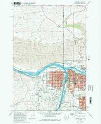
1948 Map of Clarkston
USGS Topo · Published 1948About this map
The confluence of the Snake River and Clearwater River serves as the focal point for this late-1940s survey of the Washington-Idaho border. The growing community of Clarkston is depicted in detail, alongside the nearby residential areas of Clarkston Heights and the southern riverside town of Asotin. The map reveals a landscape defined by sharp transitions between deep river canyons and high agricultural plateaus, connected by historic transportation corridors like the Inland Empire Highway and the Camas Prairie R.R. and U.P. R.R.. Local landmarks such as the Indian Timothy Bridge and the Asotin Co Airport document the mid-century infrastructure. Rural life is grounded in specific named locations like Huggins Ranch and Stout Ranch, while the upland area of Cloverland reflects the region's scattered settlement pattern across the canyon-cut terrain.
Find a feature on this map
52 named features on this map. Tap any name to fly to it.
Don’t see what you’re looking for? This feature index may not catch every label — zoom into the map to look around manually.
Map Details
Editions of this 1948 Clarkston Map
This is the sole edition of this map. No revisions or reprints were ever made.
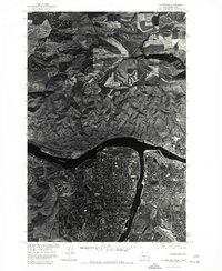
Historical Maps of Lewiston Through Time
6 maps found