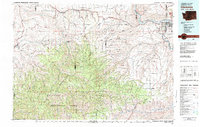
1981 Map of Clarkston
USGS Topo · Published 1981About this map
The Snake River carves a deep path through the Pacific Northwest interior on this 1981 survey, marking the jurisdictional convergence of Washington, Idaho, and Oregon. The urban centers of Clarkston and Lewiston serve as the primary hubs at this river junction, flanked by Clarkston Heights and the riverfront Hells Gate State Rec Area. The landscape transitions sharply from the agricultural Pataha Valley and settlements like Pomeroy in the north to the dense timber of the Umatilla National Forest and Wenaha-Tucannon Wilderness in the south.
Find a feature on this map
75 named features on this map. Tap any name to fly to it.
Don’t see what you’re looking for? This feature index may not catch every label — zoom into the map to look around manually.
Map Details
Editions of this 1981 Clarkston Map
2 editions found
Other maps of this area

1910 · Pullman
USGS Topo · 1:125,000

1919 · Walla Walla
USGS Topo · 1:125,000

1921 · Walla Walla
USGS Topo · 1:125,000

1937 · Pomeroy
USGS Topo · 1:96,000

1942 · Pomeroy
USGS Topo · 1:125,000

1943 · Peola
USGS Topo · 1:62,500

1943 · Saddle Butte
USGS Topo · 1:62,500

1944 · Anatone
USGS Topo · 1:62,500

1945 · Clarkston
USGS Topo · 1:62,500

1946 · Saddle Butte
USGS Topo · 1:62,500