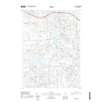
2019 Map of Clarkston
USGS Topo · Published 2019About this map
Pontiac Lake State Rec Area dominates the central landscape, a significant public space that defines the transition between the developed townships and the complex glacial hydrology of the region. The map reveals a dense network of water bodies, including Maceday Lake, Williams Lake, and Elizabeth Lake, which are interconnected by the Clinton River and the Huron River. This intricate waterway system historically dictated the settlement patterns of Clarkston and Waterford, where residential growth has closely followed the shorelines. Genealogists will find several notable burial grounds throughout the area, such as Lakeview Cem and Saint Patrick's Catholic Cem. The southeastern portion of the map is significantly marked by the Oakland County International Airport, illustrating the modern infrastructure that serves this suburban lake district. From the marshy reaches of Huron Swamp to the elevated terrain of Waterford Hill, the map documents a community deeply integrated with its aquatic environment.
Find a feature on this map
70 named features on this map. Tap any name to fly to it.
Don’t see what you’re looking for? This feature index may not catch every label — zoom into the map to look around manually.
Map Details
Editions of this 2019 Clarkston Map
This is the sole edition of this map. No revisions or reprints were ever made.
Other maps of this area

1907 · Pontiac
USGS Topo · 1:62,500

1909 · Milford
USGS Topo · 1:62,500

1920 · Holly
USGS Topo · 1:62,500

1922 · Holly
USGS Topo · 1:62,500

1936 · Wixom
USGS Topo · 1:31,680

1936 · Highland
USGS Topo · 1:31,680

1936 · Clarkston
USGS Topo · 1:31,680

1936 · Walled Lake
USGS Topo · 1:31,680

1936 · Pontiac South
USGS Topo · 1:31,680

1936 · Pontiac North
USGS Topo · 1:31,680
Featured Places
- Waterford Township, MI
- Independence Charter Township, MI
- White Lake Charter Township, MI
- Springfield Charter Township, MI
- Clarkston, MI