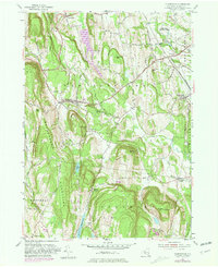
1953 Map of Clarksville
USGS Topo · Published 1981About this map
The Helderberg Mountains rise sharply in this corner of Albany County, creating a landscape of steep ridges and creek valleys that historically shaped local settlement and transit. The village of Clarksville sits at the junction of several key routes, including Delaware Avenue and Delaware Turnpike, while smaller hamlets like New Salem and Unionville are tucked near the base of the highlands. In the southern portion of the map, the massive Alcove Reservoir and the tranquil Lawson Lake stand as major hydrologic features. The map documents a transition in land use, showing the establishment of the Five Rivers Environmental Education Center near the Vloman Kill, marking a shift from the traditional agricultural and rural industry of early Albany County toward conservation and suburban residential development near Feura Bush and Stony Hill.
Find a feature on this map
56 named features on this map. Tap any name to fly to it.
Don’t see what you’re looking for? This feature index may not catch every label — zoom into the map to look around manually.
Map Details
Editions of this 1953 Clarksville Map
4 editions found
Other maps of this area

1893 · Coxsackie
USGS Topo · 1:62,500

1893 · Durham
USGS Topo · 1:62,500

1893 · Albany
USGS Topo · 1:62,500

1894 · Coxsackie
USGS Topo · 1:62,500

1894 · Durham
USGS Topo · 1:62,500

1895 · Albany
USGS Topo · 1:62,500

1898 · Albany
USGS Topo · 1:62,500

1900 · Berne
USGS Topo · 1:62,500

1903 · Berne
USGS Topo · 1:62,500

1927 · Albany
USGS Topo · 1:62,500