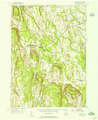
1953 Map of Clarksville
USGS Topo · Published 1956About this map
The Helderberg Mountains define the western portion of this mid-century survey, creating a dramatic escarpment that drops toward the fertile basins of the Vloman Kill and Onesquethaw Creek. This landscape is characterized by a mix of upland orchards and valley hamlets, where the historic Delmar State Game Farm sits north of Unionville. The rural economy of the early 1950s is evident in the presence of local industrial sites like the Quarry near Clarksville and the Blodget Pit No 2, while the southern reaches are anchored by the significant waters of the Alcove Reservoir. Small community hubs like New Salem and Feura Bush are connected by a network of local thoroughfares including Thacher Park Road and Indian Ladder Road. Genealogists will find value in the precise locations of the Mount Pleasant Cem and the Onesquethaw Cem tucked into the hills.
Find a feature on this map
71 named features on this map. Tap any name to fly to it.
Don’t see what you’re looking for? This feature index may not catch every label — zoom into the map to look around manually.
Map Details
Editions of this 1953 Clarksville Map
4 editions found
Other maps of this area

1893 · Coxsackie
USGS Topo · 1:62,500

1893 · Durham
USGS Topo · 1:62,500

1893 · Albany
USGS Topo · 1:62,500

1894 · Coxsackie
USGS Topo · 1:62,500

1894 · Durham
USGS Topo · 1:62,500

1895 · Albany
USGS Topo · 1:62,500

1898 · Albany
USGS Topo · 1:62,500

1900 · Berne
USGS Topo · 1:62,500

1903 · Berne
USGS Topo · 1:62,500

1927 · Albany
USGS Topo · 1:62,500