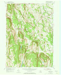
1953 Map of Clarksville
USGS Topo · Published 1973About this map
The Helderberg Mountains dominate the western horizon of this mid-century landscape, where rugged terrain meets the agricultural and industrial corridors of Albany County. Small crossroads settlements like Clarksville and New Salem are positioned along the winding routes through the hills, while the northern edge of the Alcove Reservoir and the waters of Lawson Lake highlight the area's importance for local water management. The southern reach of the Delmar State Game Farm reflects the conservation efforts of the era, contrasting with the active extraction seen at the Quarry and Gravel Pit near the eastern border.
Find a feature on this map
40 named features on this map. Tap any name to fly to it.
Don’t see what you’re looking for? This feature index may not catch every label — zoom into the map to look around manually.
Map Details
Editions of this 1953 Clarksville Map
4 editions found
Other maps of this area

1893 · Coxsackie
USGS Topo · 1:62,500

1893 · Durham
USGS Topo · 1:62,500

1893 · Albany
USGS Topo · 1:62,500

1894 · Coxsackie
USGS Topo · 1:62,500

1894 · Durham
USGS Topo · 1:62,500

1895 · Albany
USGS Topo · 1:62,500

1898 · Albany
USGS Topo · 1:62,500

1900 · Berne
USGS Topo · 1:62,500

1903 · Berne
USGS Topo · 1:62,500

1927 · Albany
USGS Topo · 1:62,500