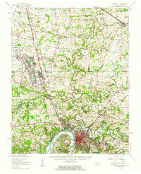
1957 Map of Clarksville
USGS Topo · Published 1963About this map
Clarksville serves as the focal point of this mid-century survey, situated at the confluence of the Red River and the Cumberland River. The landscape is transitioning during this era, noted by the presence of Barkley Lake and the significant expansion of the Fort Campbell Military Reservation and Campbell Air Force Base to the northwest. This military footprint reshaped the local geography, incorporating formerly rural areas such as Thompsonville and Hensleytown.
Find a feature on this map
64 named features on this map. Tap any name to fly to it.
Don’t see what you’re looking for? This feature index may not catch every label — zoom into the map to look around manually.
Map Details
Editions of this 1957 Clarksville Map
This is the sole edition of this map. No revisions or reprints were ever made.
Other maps of this area

1931 · Erin
USGS Topo · 1:62,500

1944 · Clarksville
USGS Topo · 1:50,000

1950 · Guthrie
USGS Topo · 1:24,000

1950 · Pembroke
USGS Topo · 1:24,000

1951 · Pembroke
USGS Topo · 1:24,000

1951 · Church Hill
USGS Topo · 1:24,000

1951 · Elkton
USGS Topo · 1:24,000

1951 · Hopkinsville
USGS Topo · 1:24,000

1951 · New Providence
USGS Topo · 1:24,000

1951 · Hammacksville
USGS Topo · 1:24,000