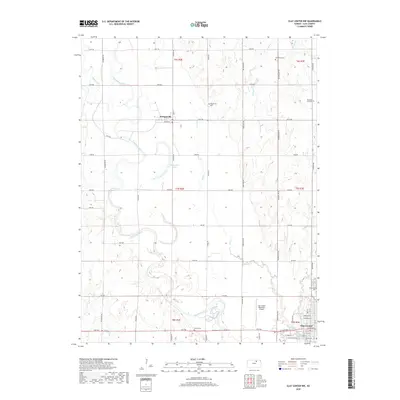
2018 Map of Clay Center NW
USGS Topo · Published 2018About this map
The Republican River meanders across this Clay County landscape, defining the character of the river valley as it passes Stillwater Lake and the settlement of Morganville. The map illustrates a mature rural grid system where section lines dictate the placement of roads like Hackberry Rd and Indian Rd, which connect various family-named burial grounds. Genealogists will find several notable sites including Swedsburg Cem, Morganville Cem, and Pleasant Hill Cem in the northern townships, while Wilson Cem and Greenwood Cem serve the area near Clay Center. The southern portion of the quadrangle shows the residential expansion and infrastructure of northern Clay Center, including the Clay Center Municipal Airport and a dense network of local streets such as W Crawford St and Lincoln Ave. Several tributaries, including Mulberry Cr and N Br Five Cr, feed into the main river channel across this agricultural region.
Find a feature on this map
51 named features on this map. Tap any name to fly to it.
Don’t see what you’re looking for? This feature index may not catch every label — zoom into the map to look around manually.
Map Details
Editions of this 2018 Clay Center NW Map
This is the sole edition of this map. No revisions or reprints were ever made.
Other maps of this area

1891 · Clay Center
USGS Topo · 1:125,000

1893 · Washington
USGS Topo · 1:125,000

1955 · Manhattan
USGS Topo · 1:250,000

1956 · Manhattan
USGS Topo · 1:250,000

1957 · Manhattan
USGS Topo · 1:250,000

1964 · Clay Center NW
USGS Topo · 1:24,000

1964 · Clay Center SW
USGS Topo · 1:24,000
1964 · Clay Center SE
USGS Topo · 1:24,000
1964 · Clay Center NE
USGS Topo · 1:24,000

1964 · Idana
USGS Topo · 1:24,000