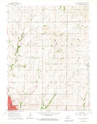
1964 Map of Clay Center NE
USGS Topo · Published 1965About this map
Clay Center serves as the focal point of this mid-1960s Kansas landscape, where the street grid of the county seat transitions into the structured agricultural sections of Garfield and Goshen townships. The map records a critical period of infrastructure, showing the Old Railroad Grade cutting diagonally through the terrain toward the settlement of Green. Local civic life is anchored by institutions like McKinley Sch and the High Sch, while the area's rural character is defined by family and community landmarks such as Hayes Ch and the Hayes Cem. Small waterways, including Spring Creek and Finney Creek, provide the natural drainage for the surrounding fields. The inclusion of Wood Airpark on the northern edge of the city highlights the mid-century evolution of local transportation alongside established landmarks like Dexter Park and the municipal Po.
Find a feature on this map
24 named features on this map. Tap any name to fly to it.
Don’t see what you’re looking for? This feature index may not catch every label — zoom into the map to look around manually.
Map Details
Editions of this 1964 Clay Center NE Map
This is the sole edition of this map. No revisions or reprints were ever made.
Other maps of this area

1886 · Junction City
USGS Topo · 1:125,000

1889 · Marysville
USGS Topo · 1:125,000

1889 · Junction City
USGS Topo · 1:125,000

1891 · Clay Center
USGS Topo · 1:125,000

1893 · Washington
USGS Topo · 1:125,000

1894 · Junction City
USGS Topo · 1:125,000

1894 · Marysville
USGS Topo · 1:125,000

1955 · Manhattan
USGS Topo · 1:250,000

1956 · Manhattan
USGS Topo · 1:250,000

1957 · Manhattan
USGS Topo · 1:250,000