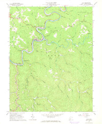
1967 Map of Clay
USGS Topo · Published 1968About this map
Elk River winds sharply through this rugged West Virginia landscape, creating dramatic loops such as Eagle Bend and Spread Bend. The town of Clay serves as a focal point, situated at a major bend in the river near Dundon and the Clay Junction. The regional economy of the late 1960s is clearly etched into the terrain, characterized by a heavy presence of gas wells scattered across the ridges and strip mines operating to the south near Bickmore.
Find a feature on this map
61 named features on this map. Tap any name to fly to it.
Don’t see what you’re looking for? This feature index may not catch every label — zoom into the map to look around manually.
Map Details
Editions of this 1967 Clay Map
2 editions found
Other maps of this area

1889 · Nicholas
USGS Topo · 1:125,000

1891 · Nicholas
USGS Topo · 1:125,000

1893 · Sutton
USGS Topo · 1:125,000

1897 · Kanawha Falls
USGS Topo · 1:125,000

1900 · Kanawha Falls
USGS Topo · 1:125,000

1901 · Nicholas
USGS Topo · 1:125,000

1901 · Kanawha Falls
USGS Topo · 1:125,000

1906 · Otter
USGS Topo · 1:62,500

1907 · Otter
USGS Topo · 1:62,500

1908 · Clay
USGS Topo · 1:48,000