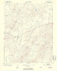
1953 Map of Claybrook
USGS Topo · Published 1955About this map
Claybrook stands as the primary settlement in this Madison County landscape, situated at a junction of roads that serve a network of rural parishes and school districts. The 1953 field check reveals a community defined by its proximity to numerous small churches and educational hubs, such as Cotton Grove Ch and Tri-Community Sch. The terrain is deeply carved by drainage systems including Gilmers Creek, Poplar Creek, and Cotton Grove Creek, which dictate the winding paths of rural routes like Hartmas Lane and Liberty Road. This era shows the transition from isolated homesteads to more connected communities, yet still preserves localized landmarks like the Lookout Tower and Salem Cem. Genealogists may find value in the specific placement of rural institutions like Progress Sch and Union Hill Ch, which anchored local life before mid-century consolidation altered the rural Tennessee map.
Find a feature on this map
33 named features on this map. Tap any name to fly to it.
Don’t see what you’re looking for? This feature index may not catch every label — zoom into the map to look around manually.
Map Details
Editions of this 1953 Claybrook Map
4 editions found
Other maps of this area

1950 · Jackson South
USGS Topo · 1:24,000

1950 · Jackson North
USGS Topo · 1:24,000

1951 · Jackson North
USGS Topo · 1:24,000

1953 · Claybrook
USGS Topo · 1:24,000

1953 · Beech Bluff
USGS Topo · 1:24,000

1955 · Luray
USGS Topo · 1:24,000

1955 · Juno
USGS Topo · 1:24,000

1956 · Blytheville
USGS Topo · 1:250,000

1959 · Medina
USGS Topo · 1:24,000

1959 · Blytheville
USGS Topo · 1:250,000