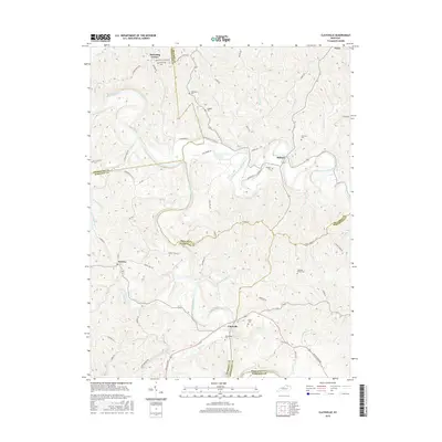
2016 Map of Claysville
USGS Topo · Published 2016About this map
The Licking River and its North Fork carve a winding course through this rural Kentucky landscape, where the boundaries of Pendleton, Bracken, Harrison, and Robertson counties converge. This 2016 survey shows a territory defined by small hilltop settlements and valley floors, notably at Claysville and Milford. The map serves as a detailed record for family history, locating numerous small burial grounds including the Browning Cem, Doggett Cem, and Hitch Cem that dot the ridges. Transportation follows the natural topography, with routes like Falmouth-Milford Rd and Kentontown Rd connecting these isolated communities. Along the many tributaries such as Beaver Cr and Harrison Creek, the intricate contour lines illustrate the deeply dissected plateau character of the region, emphasizing the traditional importance of river bottomlands for settlement and agriculture.
Find a feature on this map
74 named features on this map. Tap any name to fly to it.
Don’t see what you’re looking for? This feature index may not catch every label — zoom into the map to look around manually.
Map Details
Editions of this 2016 Claysville Map
This is the sole edition of this map. No revisions or reprints were ever made.
Other maps of this area

1929 · Cynthiana
USGS Topo · 1:48,000

1930 · Falmouth
USGS Topo · 1:48,000

1934 · Cynthiana
USGS Topo · 1:62,500

1936 · Falmouth
USGS Topo · 1:62,500

1952 · Mount Olivet
USGS Topo · 1:24,000

1952 · Piqua
USGS Topo · 1:24,000

1952 · Berlin
USGS Topo · 1:24,000

1952 · Shady Nook
USGS Topo · 1:24,000

1952 · Brooksville
USGS Topo · 1:24,000

1952 · Claysville
USGS Topo · 1:24,000