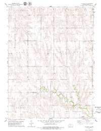
1978 Map of Clayton NE
USGS Topo · Published 1979About this map
Elk Creek winds through the southern reaches of this Norton County landscape, defining the local drainage patterns near the townships of Almelo and Lenora. The 1970s topography reveals a rural environment centered on agricultural land and specialized local industry, most notably at the Claypit and several Sandpits found along the creek bed. Near the southern margin, the Lenora Municipal Airfield serves as a modern waypoint in an otherwise traditional plains setting. The map provides a clear look at the township boundaries of Clayton, Leota, Noble, and Highland, illustrating the systematic sectioning of the Kansas prairie. Numerous localized water sources labeled simply as Well are scattered throughout the quadrangle, highlighting the vital role of groundwater management for the farmsteads and rural residents of the era.
Find a feature on this map
12 named features on this map. Tap any name to fly to it.
Don’t see what you’re looking for? This feature index may not catch every label — zoom into the map to look around manually.
Map Details
Editions of this 1978 Clayton NE Map
This is the sole edition of this map. No revisions or reprints were ever made.
Other maps of this area

1893 · Norton
USGS Topo · 1:125,000

1951 · Norton
USGS Topo · 1:62,500

1951 · Norcatur
USGS Topo · 1:62,500

1954 · Goodland
USGS Topo · 1:250,000

1955 · Beloit
USGS Topo · 1:250,000

1956 · Goodland
USGS Topo · 1:250,000

1957 · Goodland
USGS Topo · 1:250,000

1959 · Beloit
USGS Topo · 1:250,000

1978 · Clayton SW
USGS Topo · 1:24,000

1978 · Clayton
USGS Topo · 1:24,000