
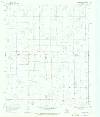
1969 Map of Claytonville NW
USGS Topo · Published 1971About this map
South Tule Draw carves a winding path across this portion of the Texas Panhandle, defining the drainage patterns of an otherwise level landscape dominated by agricultural development. The 1969 topography reveals a region transformed by groundwater extraction, marked by a dense network of wells and several smaller depressions or basins. For those researching family history in Swisher County, the presence of Wright Cem provides a specific point of reference in a rural area where few other structural landmarks are noted. Aside from a lone Storage Bin and a scattering of industrial wells, the map documents a largely open territory organized by the rigid grid of property fence lines, which were specifically selected for inclusion during the photogrammetric mapping process in 1967.
Find a feature on this map
5 named features on this map. Tap any name to fly to it.
Don’t see what you’re looking for? This feature index may not catch every label — zoom into the map to look around manually.
Map Details
Editions of this 1969 Claytonville NW Map
This is the sole edition of this map. No revisions or reprints were ever made.
Other maps of this area

1954 · Plainview
USGS Topo · 1:250,000

1958 · Plainview
USGS Topo · 1:250,000

1965 · Edmonson NE
USGS Topo · 1:24,000

1965 · Kress West
USGS Topo · 1:24,000

1965 · Tulia
USGS Topo · 1:24,000

1968 · Tule Lake
USGS Topo · 1:24,000

1969 · Love
USGS Topo · 1:24,000

1969 · Kress East
USGS Topo · 1:24,000

1969 · Claytonville
USGS Topo · 1:24,000
1969 · Providence
USGS Topo · 1:24,000