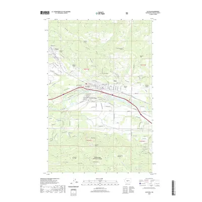
2020 Map of Cle Elum
USGS Topo · Published 2020About this map
Cle Elum and its sister settlements of Roslyn and South Cle Elum anchor this 2020 landscape, where the legacy of the local coal industry is preserved in street names like Coal Mine Way, No 9 Mine Rd, and Tipple Hill Loop. The Yakima River and the Main Canal cut through the valley, providing a critical water network between the high elevations of Cle Elum Ridge and the Wenatchee National Forest to the south. Local history is marked at the Laurel Hill Memorial Cem and the Cle Elum Municipal Airport, while the surrounding terrain is defined by a series of steep drainages including Greens Canyon and Carlson Canyon. The southern portion of the map is dominated by the prominent lookout at Peoh Point, overlooking the agricultural and transportation corridors that have shaped the Kittitas County region.
Find a feature on this map
129 named features on this map. Tap any name to fly to it.
Don’t see what you’re looking for? This feature index may not catch every label — zoom into the map to look around manually.
Map Details
Editions of this 2020 Cle Elum Map
This is the sole edition of this map. No revisions or reprints were ever made.
Other maps of this area

1897 · Mount Stuart
USGS Topo · 1:125,000

1901 · Snoqualmie Pass
USGS Topo · 1:125,000

1902 · Mount Stuart
USGS Topo · 1:125,000

1903 · Snoqualmie
USGS Topo · 1:125,000

1957 · Wenatchee
USGS Topo · 1:250,000

1958 · Cle Elum
USGS Topo · 1:62,500

1961 · Mount Stuart
USGS Topo · 1:62,500

1961 · Easton
USGS Topo · 1:62,500

1961 · Kachess Lake
USGS Topo · 1:62,500

1975 · Snoqualmie Pass
USGS Topo · 1:100,000