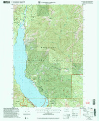
2003 Map of Cle Elum Lake
USGS Topo · Published 2006About this map
Cle Elum Lake dominates the western portion of this terrain, served by the Cle Elum River and numerous drainages like French Cabin Creek and Thorp Creek. The landscape transition from the reservoir's edge to high points such as Hex Mountain and Sasse Mountain reflects a region defined by its water management and forestry. Near the southern shore, Wish Poosh and Lakedale mark small pockets of activity alongside the Boat Ramp, while the interior of the Wenatchee National Forest contains evidence of early industrial interests. Traces of resource extraction appear in the southeastern quadrant, where a Strip Mine and an Adit are located along the slopes of Cle Elum Ridge, suggesting a history of mineral exploration between the lake and the West Fork Teanaway River basin.
Find a feature on this map
37 named features on this map. Tap any name to fly to it.
Don’t see what you’re looking for? This feature index may not catch every label — zoom into the map to look around manually.
Map Details
Editions of this 2003 Cle Elum Lake Map
This is the sole edition of this map. No revisions or reprints were ever made.
Other maps of this area

1897 · Mount Stuart
USGS Topo · 1:125,000

1901 · Snoqualmie Pass
USGS Topo · 1:125,000

1902 · Mount Stuart
USGS Topo · 1:125,000

1903 · Snoqualmie
USGS Topo · 1:125,000

1957 · Wenatchee
USGS Topo · 1:250,000

1958 · Cle Elum
USGS Topo · 1:62,500

1961 · Mount Stuart
USGS Topo · 1:62,500

1961 · Easton
USGS Topo · 1:62,500

1961 · Kachess Lake
USGS Topo · 1:62,500

1975 · Snoqualmie Pass
USGS Topo · 1:100,000