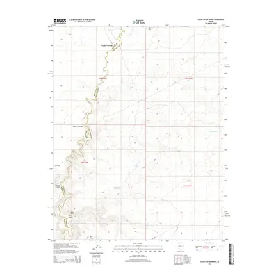
2014 Map of Clear Water Spring
USGS Topo · Published 2014About this map
Kanab Cr carves a deep, winding path through this corner of Northern Arizona, marking a natural boundary between Mohave and Coconino counties. The landscape is defined by its drainages and high points, including Clear Water Point and Loco Point. Early travel routes and livestock management are evident through the naming of river crossings and water catchments. These include Nagles Crossing and Booze Crossing, which provide access across the canyon floor, as well as several essential desert water sources like Filarea Tank, Rock Canyon Reservoir, and the namesake Clear Water Spring. Remote access is maintained through Nagles Rd and various Bureau of Land Management routes, connecting these geographic landmarks across a high-desert plateau characterized by prominent features like the Flat Tops to the north.
Find a feature on this map
24 named features on this map. Tap any name to fly to it.
Don’t see what you’re looking for? This feature index may not catch every label — zoom into the map to look around manually.
Map Details
Editions of this 2014 Clear Water Spring Map
This is the sole edition of this map. No revisions or reprints were ever made.
Other maps of this area

1886 · Kaibab
USGS Topo · 1:250,000

1953 · Grand Canyon
USGS Topo · 1:250,000

1954 · Fredonia NW
USGS Topo · 1:24,000

1954 · Shinarump NW
USGS Topo · 1:24,000

1954 · Fredonia SW
USGS Topo · 1:24,000

1954 · Fredonia NE
USGS Topo · 1:24,000

1954 · Fredonia
USGS Topo · 1:62,500

1957 · Grand Canyon
USGS Topo · 1:250,000

1957 · Shinarump SW
USGS Topo · 1:24,000
1957 · Shinarump
USGS Topo · 1:62,500