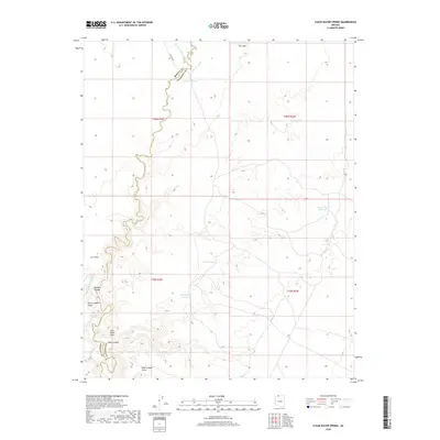
2018 Map of Clear Water Spring
USGS Topo · Published 2018About this map
Kanab Cr carves a deep, winding path through the landscape, defining the administrative boundary between Mohave and Coconino counties. This high-desert terrain is marked by essential water sources for cattle and wildlife, including Clear Water Spring, Quickwater Spring, and the man-made Spooks Knoll Reservoir. The map illustrates a network of drainage systems like Sandy Canyon Wash and Johnson Wash that feed into the central canyon system. Prominent overlooks such as Loco Point and Burnt Canyon Point provide vantage points over the canyon floors, where Rock Canyon Reservoir and Filarea Tank serve as critical collection points in an arid environment. The layout of section lines and township markers from the Public Land Survey System overlay the natural topography, showing the intersection of human management and the physical geography of the Flat Tops region.
Find a feature on this map
21 named features on this map. Tap any name to fly to it.
Don’t see what you’re looking for? This feature index may not catch every label — zoom into the map to look around manually.
Map Details
Editions of this 2018 Clear Water Spring Map
This is the sole edition of this map. No revisions or reprints were ever made.
Other maps of this area

1886 · Kaibab
USGS Topo · 1:250,000

1953 · Grand Canyon
USGS Topo · 1:250,000

1954 · Fredonia NW
USGS Topo · 1:24,000

1954 · Shinarump NW
USGS Topo · 1:24,000

1954 · Fredonia SW
USGS Topo · 1:24,000

1954 · Fredonia NE
USGS Topo · 1:24,000

1954 · Fredonia
USGS Topo · 1:62,500

1957 · Grand Canyon
USGS Topo · 1:250,000

1957 · Shinarump SW
USGS Topo · 1:24,000
1957 · Shinarump
USGS Topo · 1:62,500