
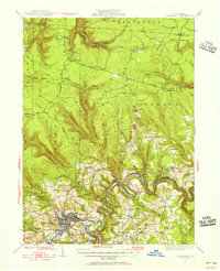
1929 Map of Clearfield
USGS Topo · Published 1929About this map
The West Branch Susquehanna River carves a winding path through this central Pennsylvania landscape, anchoring the bustling riverfront seat of Clearfield. In the late 1920s, the town serves as a vital transportation hub where the New York Central Railroad meets the Lakes To Sea Highway, facilitating the movement of local timber and coal. Outside the industrial center, a network of rural schoolhouses and churches, such as the Leonard Waterford Sch and Goshen Ch, reveals the social fabric of early 20th-century life in the surrounding townships.
Find a feature on this map
65 named features on this map. Tap any name to fly to it.
Don’t see what you’re looking for? This feature index may not catch every label — zoom into the map to look around manually.
Map Details
Editions of this 1929 Clearfield Map
2 editions found
Other maps of this area

1903 · Curwensville
USGS Topo · 1:62,500

1903 · Houtzdale
USGS Topo · 1:62,500

1905 · Houtzdale
USGS Topo · 1:62,500

1922 · Philipsburg
USGS Topo · 1:62,500

1929 · Karthaus
USGS Topo · 1:62,500

1929 · Penfield
USGS Topo · 1:62,500

1932 · Clearfield
USGS Topo · 1:62,500

1932 · Penfield
USGS Topo · 1:62,500

1932 · Karthaus
USGS Topo · 1:62,500

1939 · Curwensville
USGS Topo · 1:62,500