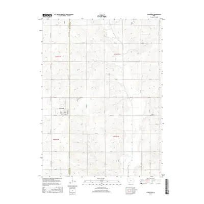
2015 Map of Clearfield
USGS Topo · Published 2015About this map
Clearfield occupies the western edge of this 2015 study, situated at the boundary where Taylor and Ringgold counties meet. The town's grid is clearly defined by streets such as Broadway St and Washington St, while its surrounding rural landscape is marked by a legacy of family and community burial grounds. These include the Clearfield Cem just north of town, and the more distant Rising Sun Cem, Tindle Cem, and Cabaret Cem. The terrain is shaped by the southward flow of the Platte River and its tributaries, including Turkey Cr and Honey Cr. This modern survey provides an exacting record of the rural road network, showing how primary routes like Co Hwy J23 and the county-line Tay-Gold Ave connect these agricultural uplands.
Find a feature on this map
49 named features on this map. Tap any name to fly to it.
Don’t see what you’re looking for? This feature index may not catch every label — zoom into the map to look around manually.
Map Details
Editions of this 2015 Clearfield Map
This is the sole edition of this map. No revisions or reprints were ever made.
Other maps of this area

1940 · Blockton
USGS Topo · 1:62,500

1940 · Bedford
USGS Topo · 1:62,500

1943 · Bedford
USGS Topo · 1:62,500

1943 · Blockton
USGS Topo · 1:62,500

1955 · Nebraska City
USGS Topo · 1:250,000

1957 · Nebraska City
USGS Topo · 1:250,000

1958 · Nebraska City
USGS Topo · 1:250,000

1980 · Merle Junction
USGS Topo · 1:24,000

1980 · Lenox
USGS Topo · 1:24,000
1980 · Conway
USGS Topo · 1:24,000