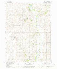
1981 Map of Clearfield
USGS Topo · Published 1981About this map
Clearfield serves as the primary hub of this rural landscape, straddling the border of Taylor and Ringgold Counties in southern Iowa. The town is oriented around the Burlington Northern railroad corridor, reflecting the classic Midwestern settlement pattern where rail access dictated growth and commerce. The surrounding terrain is defined by a dendritic network of waterways, including Honey Creek, Turkey Creek, and Gard Branch, which feed into the southward-flowing Platte River.
Find a feature on this map
16 named features on this map. Tap any name to fly to it.
Don’t see what you’re looking for? This feature index may not catch every label — zoom into the map to look around manually.
Map Details
Editions of this 1981 Clearfield Map
This is the sole edition of this map. No revisions or reprints were ever made.
Other maps of this area

1940 · Blockton
USGS Topo · 1:62,500

1940 · Bedford
USGS Topo · 1:62,500

1943 · Bedford
USGS Topo · 1:62,500

1943 · Blockton
USGS Topo · 1:62,500

1955 · Nebraska City
USGS Topo · 1:250,000

1957 · Nebraska City
USGS Topo · 1:250,000

1958 · Nebraska City
USGS Topo · 1:250,000

1980 · Merle Junction
USGS Topo · 1:24,000

1980 · Lenox
USGS Topo · 1:24,000
1980 · Conway
USGS Topo · 1:24,000