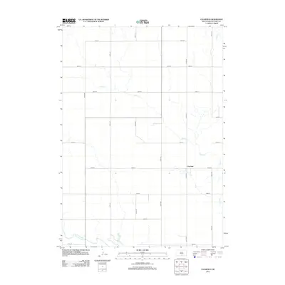
2012 Map of Clearfield
USGS Topo · Published 2012About this map
Clearfield serves as the primary settlement hub within this section of the High Plains, situated at the junction of a systematic grid of local thoroughfares. The landscape is defined by the winding course of the Keya Paha River along the southwestern corner and the drainage network of Willow Cr and Dog Ear Cr. This 2012 survey illustrates the enduring agricultural character of Tripp County, where long-distance roads like 307th Ave and 292nd St connect isolated ranching and farming operations. The map provides a clear look at the rural infrastructure of the early 21st century, showing how the land is partitioned by miles of section-line roads, such as 287th St and 304th Ave, which facilitate movement through this open prairie environment.
Find a feature on this map
19 named features on this map. Tap any name to fly to it.
Don’t see what you’re looking for? This feature index may not catch every label — zoom into the map to look around manually.
Map Details
Editions of this 2012 Clearfield Map
This is the sole edition of this map. No revisions or reprints were ever made.
Other maps of this area

1955 · Martin
USGS Topo · 1:250,000

1955 · Mitchell
USGS Topo · 1:250,000

1958 · Martin
USGS Topo · 1:250,000

1959 · Mitchell
USGS Topo · 1:250,000

1982 · Witten SE
USGS Topo · 1:25,000
1982 · Millboro
USGS Topo · 1:24,000

1982 · Keyapaha SE
USGS Topo · 1:24,000

1982 · Witten SW
USGS Topo · 1:25,000
1982 · Clearfield
USGS Topo · 1:24,000
1982 · Keyapaha NW
USGS Topo · 1:24,000