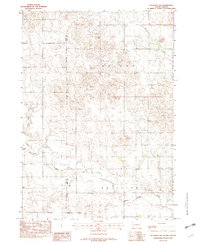
1982 Map of Keyapaha NW
USGS Topo · Published 1982About this map
The Keya Paha River snakes through the southern reaches of this South Dakota landscape, defining the character of the terrain along the Rosebud Indian Reservation Boundary. This 1982 survey illustrates a sparsely populated region of Tripp and Todd Counties, where rural life centered on local institutions like Gabler Sch and the Jerusalem Cem. The drainage network is intricately mapped, featuring Willow Creek, Crazy Hole Creek, and Eagle Cr, which carve through the plains. The map reflects a period of stable land use, with township divisions such as Wright, Hol S C L A W, and Wortman providing a framework for the agricultural and ranching properties that dominate the area.
Find a feature on this map
12 named features on this map. Tap any name to fly to it.
Don’t see what you’re looking for? This feature index may not catch every label — zoom into the map to look around manually.
Map Details
Editions of this 1982 Keyapaha NW Map
This is the sole edition of this map. No revisions or reprints were ever made.
Other maps of this area

1955 · Martin
USGS Topo · 1:250,000

1958 · Martin
USGS Topo · 1:250,000

1982 · Witten SE
USGS Topo · 1:25,000

1982 · Keyapaha SE
USGS Topo · 1:24,000

1982 · Witten SW
USGS Topo · 1:25,000
1982 · Clearfield
USGS Topo · 1:24,000

1982 · Hidden Timber SE
USGS Topo · 1:24,000

1982 · Okreek SE
USGS Topo · 1:24,000
1982 · Hidden Timber NE
USGS Topo · 1:24,000
1982 · Keyapaha
USGS Topo · 1:24,000