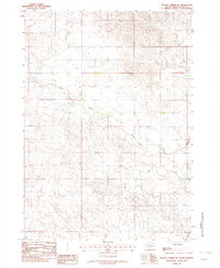
1982 Map of Hidden Timber NE
USGS Topo · Published 1982About this map
The Rosebud Indian Reservation dominates this landscape, showing a portion of Todd County where the winding Keya Paha River cuts across the plains. This 1982 provisional survey captures a largely rural expanse defined by watercourses and section lines rather than dense town centers. In the eastern reaches, the hydrology is marked by the confluence of Crazy Hole Creek and Eagle Creek as they join the river system. The map reflects a period of modern ranching and tribal land management, emphasizing the natural topography and the sparse network of improved and unimproved roads that navigate the subtle changes in elevation throughout the southern South Dakota prairie.
Find a feature on this map
7 named features on this map. Tap any name to fly to it.
Don’t see what you’re looking for? This feature index may not catch every label — zoom into the map to look around manually.
Map Details
Editions of this 1982 Hidden Timber NE Map
This is the sole edition of this map. No revisions or reprints were ever made.
Other maps of this area

1955 · Martin
USGS Topo · 1:250,000

1958 · Martin
USGS Topo · 1:250,000

1982 · Hidden Timber
USGS Topo · 1:24,000

1982 · Okreek
USGS Topo · 1:25,000

1982 · Witten SW
USGS Topo · 1:25,000

1982 · Hidden Timber SE
USGS Topo · 1:24,000

1982 · Okreek SE
USGS Topo · 1:24,000
1982 · Keyapaha NW
USGS Topo · 1:24,000
1982 · Keyapaha
USGS Topo · 1:24,000
1982 · Littleburg
USGS Topo · 1:24,000