1982 Map of Okreek
USGS Topo · Published 1982About this map
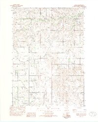
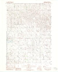
Okreek stands as the primary settlement in this 1982 provisional survey of the Rosebud Indian Reservation. The community layout is clearly defined, featuring a Post Office and essential local landmarks such as St Peters Ch, Calvary Ch, and a local Cem. The landscape is etched by the meandering courses of Oak Creek to the north and Antelope Creek to the south, highlighting the importance of these water sources to the surrounding prairie. This edition, compiled from 1974 aerial photography and field-checked in 1977, provides a clear view of the rural infrastructure of Todd County during the late 1970s and early 1980s, including a Radio Tower and the municipal Sewage Lagoon.
Find a feature on this map
12 named features on this map. Tap any name to fly to it.
Don’t see what you’re looking for? This feature index may not catch every label — zoom into the map to look around manually.
Map Details
Editions of this 1982 Okreek Map
This is the sole edition of this map. No revisions or reprints were ever made.
Other maps of this area

1955 · Martin
USGS Topo · 1:250,000

1958 · Martin
USGS Topo · 1:250,000

1982 · Mission NE
USGS Topo · 1:24,000
1982 · Olsonville
USGS Topo · 1:24,000
1982 · Hidden Timber
USGS Topo · 1:24,000
1982 · Okreek SE
USGS Topo · 1:24,000
1982 · Mission SE
USGS Topo · 1:24,000

1982 · Mosher
USGS Topo · 1:25,000
1982 · Hidden Timber NE
USGS Topo · 1:24,000

1982 · Wood South
USGS Topo · 1:24,000