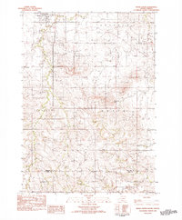
1982 Map of Wood South
USGS Topo · Published 1982About this map
The Rosebud Indian Reservation Boundary defines the southern reach of this landscape, where the prairie transitions across the Mellette Co Todd Co line. Near the settlement of Wood, the local community infrastructure is clearly visible, featuring a Grandstand Rodeo Arena and an Athletic Field, reflecting the social centers of this rural hub in the early 1980s. To the south, the topography is dominated by prominent landforms such as Rattlesnake Butte and Fairview Butte, which rise above the surrounding plains.
Find a feature on this map
13 named features on this map. Tap any name to fly to it.
Don’t see what you’re looking for? This feature index may not catch every label — zoom into the map to look around manually.
Map Details
Editions of this 1982 Wood South Map
This is the sole edition of this map. No revisions or reprints were ever made.
Other maps of this area

1955 · Martin
USGS Topo · 1:250,000

1958 · Martin
USGS Topo · 1:250,000

1982 · Mission NE
USGS Topo · 1:24,000

1982 · White River SE
USGS Topo · 1:24,000

1982 · Wood North
USGS Topo · 1:24,000

1982 · Badnation SE
USGS Topo · 1:25,000

1982 · Okreek
USGS Topo · 1:25,000

1982 · Okreek SE
USGS Topo · 1:24,000
1982 · Mission SE
USGS Topo · 1:24,000

1982 · Mosher
USGS Topo · 1:25,000