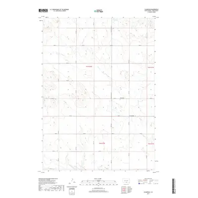
2017 Map of Clearfield
USGS Topo · Published 2017About this map
Clearfield stands at the intersection of 292nd St and 307th Ave, serving as a central point in this prairie landscape of Tripp County. The terrain is defined by a series of intermittent drainages, most notably Willow Cr, which meanders across the central sections before the land slopes south toward the Keya Paha River. To the north, Little Dog Ear Lake and Dog Ear Cr provide distinct landmarks in a region largely structured by the Public Land Survey System grid. For those researching local history, the presence of the Saint Boniface Catholic Cem north of the main settlement offers a specific site for genealogical study. The map illustrates how S Dakota Highway 53 acts as the primary north-south artery, connecting these remote agricultural sections and high-ground ridges.
Find a feature on this map
26 named features on this map. Tap any name to fly to it.
Don’t see what you’re looking for? This feature index may not catch every label — zoom into the map to look around manually.
Map Details
Editions of this 2017 Clearfield Map
This is the sole edition of this map. No revisions or reprints were ever made.
Other maps of this area

1955 · Martin
USGS Topo · 1:250,000

1955 · Mitchell
USGS Topo · 1:250,000

1958 · Martin
USGS Topo · 1:250,000

1959 · Mitchell
USGS Topo · 1:250,000

1982 · Witten SE
USGS Topo · 1:25,000
1982 · Millboro
USGS Topo · 1:24,000

1982 · Keyapaha SE
USGS Topo · 1:24,000

1982 · Witten SW
USGS Topo · 1:25,000
1982 · Clearfield
USGS Topo · 1:24,000
1982 · Keyapaha NW
USGS Topo · 1:24,000