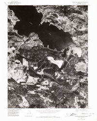
1977 Map of Clearlake Highlands
USGS Topo · Published 1980About this map
Clear Lake dominates the upper half of this 1977 orthophotograph, its deep waters and irregular shoreline defining the geography of the surrounding Lake County landscape. On the eastern shore, the residential and commercial patterns of Clearlake Highlands are clearly visible, showcasing the community's development during the late 1970s. This aerial-based survey provides a unique visual record of the land beyond the primary lake, including the smaller, landlocked Borax Lake to the north and the distinct basin of Thurston Lake to the south. The transition from the dense street grids near the waterfront to the orchards and undeveloped terrain further inland illustrates the area's growth and its reliance on the water's edge for settlement. For those studying California's largest natural freshwater lake, this document captures the exact footprint of the peninsula and the adjacent highlands at a moment of significant local expansion.
Find a feature on this map
4 named features on this map. Tap any name to fly to it.
Don’t see what you’re looking for? This feature index may not catch every label — zoom into the map to look around manually.
Map Details
Editions of this 1977 Clearlake Highlands Map
This is the sole edition of this map. No revisions or reprints were ever made.
Other maps of this area

1921 · Kelseyville
USGS Topo · 1:62,500

1924 · Bartlett Springs
USGS Topo · 1:62,500

1938 · Lakeport
USGS Topo · 1:62,500

1942 · Bartlett Springs
USGS Topo · 1:62,500

1943 · Kelseyville
USGS Topo · 1:62,500

1944 · Bartlett Springs
USGS Topo · 1:62,500

1945 · Lower Lake
USGS Topo · 1:62,500

1947 · Santa Rosa
USGS Topo · 1:250,000

1949 · Santa Rosa
USGS Topo · 1:250,000

1951 · Lakeport
USGS Topo · 1:62,500