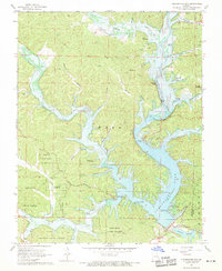
1968 Map of Clearwater Dam
USGS Topo · Published 1969About this map
Bozarth State Forest blankets much of this 1960s landscape, where the Black River is transformed by the massive infrastructure of the Clearwater Lake reservoir. This late-sixties topography captures the region as a recreational and conservation hub, featuring established public grounds like Webb Creek Public Use Area and Thurman Point Public Use Area along the convoluted shoreline.
Find a feature on this map
46 named features on this map. Tap any name to fly to it.
Don’t see what you’re looking for? This feature index may not catch every label — zoom into the map to look around manually.
Map Details
Editions of this 1968 Clearwater Dam Map
3 editions found
Other maps of this area

1926 · Des Arc
USGS Topo · 1:62,500

1929 · Des Arc
USGS Topo · 1:62,500

1932 · Piedmont
USGS Topo · 1:62,500

1935 · Piedmont
USGS Topo · 1:62,500

1943 · Ellington
USGS Topo · 1:62,500

1943 · Lesterville
USGS Topo · 1:62,500

1945 · Ellington
USGS Topo · 1:62,500

1946 · Lesterville
USGS Topo · 1:62,500

1949 · Rolla
USGS Topo · 1:250,000

1953 · Rolla
USGS Topo · 1:250,000