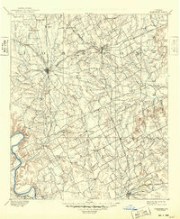
1894 Map of Cleburne
USGS Topo · Published 1949About this map
The rail-driven growth of North Central Texas is evident in this late 19th-century survey, where the Gulf Colorado and Santa Fe Railway and the Missouri Kansas and Texas Railway converge at the regional hub of Cleburne. The landscape transitions from the upland settlements of Alvarado and Joshua toward the river valleys to the south. Along the western edge, the Brazos River carves a deep path through the terrain near Fowler, while the Nolands River drainage system dictates the placement of early communities like Blum. Smaller, rural points of interest such as Stubblefield, Files Valley, and the curiously named X Roads provide essential landmarks for genealogists tracking family landholdings in Johnson and Hill Counties. The map also captures several points along the southern border near the historic site of Fort Graham and the developing seat at Hillsboro, showing the established road networks connecting these frontier trading centers.
Find a feature on this map
65 named features on this map. Tap any name to fly to it.
Don’t see what you’re looking for? This feature index may not catch every label — zoom into the map to look around manually.
Map Details
Editions of this 1894 Cleburne Map
5 editions found
Other maps of this area

1888 · Meridian
USGS Topo · 1:125,000

1889 · Granbury
USGS Topo · 1:125,000

1891 · Weatherford
USGS Topo · 1:125,000

1891 · Dallas
USGS Topo · 1:125,000

1891 · Cleburne
USGS Topo · 1:125,000

1892 · Waco
USGS Topo · 1:125,000

1893 · Dallas
USGS Topo · 1:125,000

1893 · Weatherford
USGS Topo · 1:125,000

1894 · Meridian
USGS Topo · 1:125,000

1894 · Cleburne
USGS Topo · 1:125,000