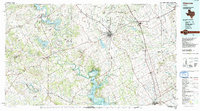
1985 Map of Cleburne
USGS Topo · Published 1991About this map
The Brazos River carves a winding path through this region, defining the landscape with dramatic horseshoe bends such as Carmichael Bend, De Cordova Bend, and Kimball Bend. The mid-1980s saw this area of North Texas anchored by growing hubs like Cleburne and Granbury, with the infrastructure of massive water projects including Whitney Lake and Squaw Creek Reservoir well established. Significant tracts of protected land are documented, most notably Dinosaur Valley State Park near Glen Rose and Cleburne State Park to the southwest of the city.
Find a feature on this map
111 named features on this map. Tap any name to fly to it.
Don’t see what you’re looking for? This feature index may not catch every label — zoom into the map to look around manually.
Map Details
Editions of this 1985 Cleburne Map
2 editions found
Other maps of this area

1888 · Hamilton
USGS Topo · 1:125,000

1888 · Meridian
USGS Topo · 1:125,000

1889 · Granbury
USGS Topo · 1:125,000

1890 · Stephenville
USGS Topo · 1:125,000

1891 · Weatherford
USGS Topo · 1:125,000

1891 · Dallas
USGS Topo · 1:125,000

1891 · Palo Pinto
USGS Topo · 1:125,000

1891 · Cleburne
USGS Topo · 1:125,000

1892 · Waco
USGS Topo · 1:125,000

1893 · Dallas
USGS Topo · 1:125,000