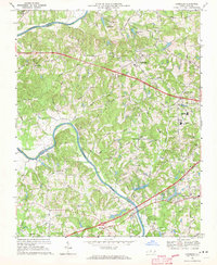
1968 Map of Clemmons
USGS Topo · Published 1970About this map
The Yadkin River defines the western edge of this Piedmont landscape, carving the Yadkin Valley where the borders of Forsyth, Yadkin, and Davie counties meet. In the late 1960s, this area reflects a period of suburban transition, centered on the growing community of Clemmons and the village of Lewisville. Educational and recreational development is prominent, seen in the campus of West Forsyth High School and the extensive grounds of Tanglewood Park near the riverbanks.
Find a feature on this map
56 named features on this map. Tap any name to fly to it.
Don’t see what you’re looking for? This feature index may not catch every label — zoom into the map to look around manually.
Map Details
Editions of this 1968 Clemmons Map
3 editions found
Other maps of this area

1891 · Yadkinville
USGS Topo · 1:125,000

1893 · Statesville
USGS Topo · 1:125,000

1893 · Yadkinville
USGS Topo · 1:125,000

1950 · Winston-Salem West
USGS Topo · 1:24,000

1951 · Winston-Salem West
USGS Topo · 1:24,000

1951 · Rural Hall
USGS Topo · 1:24,000

1953 · Charlotte
USGS Topo · 1:250,000

1953 · Winston-Salem
USGS Topo · 1:250,000

1954 · Charlotte
USGS Topo · 1:250,000

1955 · Winston-Salem
USGS Topo · 1:250,000