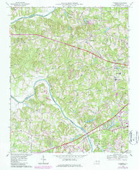
1968 Map of Clemmons
USGS Topo · Published 1986About this map
Tanglewood Park and the winding Yadkin River anchor this landscape along the border of Forsyth, Yadkin, and Davie counties. The terrain reflects a mix of growing residential communities and traditional rural centers, with Lewisville and Clemmons showing significant expansion by the late 1960s. Rural life is grounded by a dense network of community churches and schools, including Grapevine Ch, New Hope Ch, and Enon Sch.
Find a feature on this map
56 named features on this map. Tap any name to fly to it.
Don’t see what you’re looking for? This feature index may not catch every label — zoom into the map to look around manually.
Map Details
Editions of this 1968 Clemmons Map
3 editions found
Other maps of this area

1891 · Yadkinville
USGS Topo · 1:125,000

1893 · Statesville
USGS Topo · 1:125,000

1893 · Yadkinville
USGS Topo · 1:125,000

1950 · Winston-Salem West
USGS Topo · 1:24,000

1951 · Winston-Salem West
USGS Topo · 1:24,000

1951 · Rural Hall
USGS Topo · 1:24,000

1953 · Charlotte
USGS Topo · 1:250,000

1953 · Winston-Salem
USGS Topo · 1:250,000

1954 · Charlotte
USGS Topo · 1:250,000

1955 · Winston-Salem
USGS Topo · 1:250,000