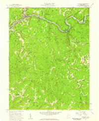
1957 Map of Clendenin
USGS Topo · Published 1959About this map
The town of Clendenin serves as a focal point for this 1957 survey, situated where the Baltimore and Ohio railroad follows the winding banks of the Elk River. The map captures a transition in West Virginia’s industrial landscape, with dozens of gas wells peppered throughout the high ridges of Big Sandy and Duval districts. To the northwest, the settlement of Reamer includes the Sybial PO post office designation, while scattered mountain communities like Turner and Corton are anchored by local institutions such as Turner Sch and Blessed Hope Ch. The rugged interior is defined by deep drainage basins like Falling Rock Creek and Turkey Creek, where smaller schools such as Eds Fork Sch and Dry Ridge Sch served the rural population before mid-century consolidation. Evidence of extractive industry is visible in several Strip Mine operations located near Barren Creek and Porter Cr.
Find a feature on this map
67 named features on this map. Tap any name to fly to it.
Don’t see what you’re looking for? This feature index may not catch every label — zoom into the map to look around manually.
Map Details
Editions of this 1957 Clendenin Map
2 editions found
Other maps of this area

1897 · Kanawha Falls
USGS Topo · 1:125,000

1900 · Kanawha Falls
USGS Topo · 1:125,000

1901 · Kanawha Falls
USGS Topo · 1:125,000

1906 · Otter
USGS Topo · 1:62,500

1906 · Walton
USGS Topo · 1:62,500

1907 · Otter
USGS Topo · 1:62,500

1907 · Walton
USGS Topo · 1:62,500

1907 · Clendenin
USGS Topo · 1:62,500

1908 · Clay
USGS Topo · 1:48,000

1909 · Clendenin
USGS Topo · 1:62,500