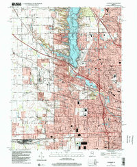
1998 Map of Clermont
USGS Topo · Published 2002About this map
Eagle Creek Reservoir and its surrounding Eagle Creek Park dominate the landscape of northwestern Marion County in this late-1990s record. The map reveals the suburban expansion pushing westward from Indianapolis toward the Hendricks County line, where the industrial presence of the Big Four Yard and the motorsports legacy of Indianapolis Raceway Park anchor the local economy.
Find a feature on this map
71 named features on this map. Tap any name to fly to it.
Don’t see what you’re looking for? This feature index may not catch every label — zoom into the map to look around manually.
Map Details
Editions of this 1998 Clermont Map
This is the sole edition of this map. No revisions or reprints were ever made.
Other maps of this area

1948 · Maywood
USGS Topo · 1:24,000

1948 · Indianapolis West
USGS Topo · 1:24,000

1952 · Carmel
USGS Topo · 1:24,000

1953 · Bridgeport
USGS Topo · 1:24,000

1953 · Fayette
USGS Topo · 1:24,000

1953 · Brownsburg
USGS Topo · 1:24,000

1953 · Zionsville
USGS Topo · 1:24,000

1953 · Plainfield
USGS Topo · 1:24,000

1953 · Clermont
USGS Topo · 1:24,000

1953 · Indianapolis
USGS Topo · 1:250,000