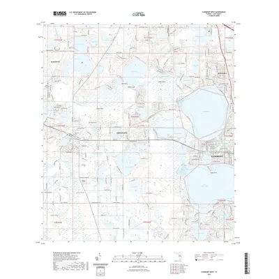
2021 Map of Clermont West
USGS Topo · Published 2021About this map
The Palatlakaha River winds through a dense network of lakes and wetlands in this 2021 survey of Lake County. Centered on the growing communities of Groveland, Clermont, Mascotte, and Minneola, the landscape is defined by its complex hydrology, featuring dozens of named water bodies from the expansive Lake Minnehaha to smaller basins like Lake Audrey and Lake David. The map captures a mix of residential expansion and preserved open space, with numerous family and community burial sites such as Woods Boyd Family Cem and Greenwood Cem providing direct links to the area's pioneer heritage. Aviation history is also present through smaller facilities like Sheets Airport and Osborn Airfield. This modern topography documents how these central Florida settlements have integrated with the surrounding terrain, including named landforms like Edges Island and Hooks Point that rise from the water-rich environment.
Find a feature on this map
214 named features on this map. Tap any name to fly to it.
Don’t see what you’re looking for? This feature index may not catch every label — zoom into the map to look around manually.
Map Details
Editions of this 2021 Clermont West Map
This is the sole edition of this map. No revisions or reprints were ever made.
Other maps of this area

1955 · Orlando
USGS Topo · 1:250,000

1957 · Orlando
USGS Topo · 1:250,000

1958 · Orlando
USGS Topo · 1:250,000

1959 · Lake Nellie
USGS Topo · 1:24,000

1959 · Lake Louisa
USGS Topo · 1:24,000
1960 · Bay Lake
USGS Topo · 1:24,000

1962 · Orlando
USGS Topo · 1:250,000

1962 · Clermont East
USGS Topo · 1:24,000

1962 · Astatula
USGS Topo · 1:24,000
1969 · Center Hill
USGS Topo · 1:24,000